Modern day Iraq is the third largest population in Southwest Asia that has approximately 22.4 million people in it. The government of Iraq urges population growth for their country with having their fertility rates at the highest in the world! Because of this, forty-six percent of the population is below the age of fifteen. But what was Iraq’s population like back then and how did it get to be where it is today?
Iraq back in the Before Christ era was known for how fertile it was, which had many plants grow due to the rich soil and rain. This area was actually known to be the Fertile Crescent that we previously learned about. Because of the green land providing plants to eat and different water sources, this area brought in different animals and people. The water sources came from the Tigris and Euphrates rivers. This made it a livable place for plants, animals, and people.
Back in 4800 BC, the first people to settle in this area were the Sumerians which are the people of ancient Babylonia. Iraq was once called Mesopotamia which is a Greek name for ‘land between rivers’. This was the making of the arrival of the first human civilization. In fact, the Sumerians developed the first known system of writing known as the Sumerian Language and even invented a mathematical system based on the number sixty which is where we get our sixty seconds in a minute today.
As people were getting adjusted to living in such a rich soiled area, farming began. People began to discover planting seeds in 8000 BC which was convenient with living in such a perfect environment. Sumerians began to grow barley, wheat, chickpeas, onions, dates, and lettuce. Because of the water sources from the rivers, the rich soil, and the rain, people could domesticate more wild plants than any other region. This then lead to the domestication of the native animals like sheep, goats, cows, donkeys, oxen, and pigs.
Farming, domesticating animals, and the climate made living in Mesopotamia prosper and eventually made cities. Early day Iraq, or Mesopotamia, created the first city in the world which was known to begin back in 10,000 BC. The people who lived here then developed city states, a nation that is only one city, rather than having several cities. With creating city-states, thick walls were bordered around each state because they were often at war with each other. These city-states included Eridu which was the first city according to the Sumerians with a population of roughly about four thousand people, Uruk being the largest population with eighty thousand people, Ur populating around sixty-five thousand people, and Lagash having between thirty and thirty-six thousand people. This incredible time period began a great human migration from the farmland into the cities.
Mesopotamia, known as modern day Iraq, was the ideal place for people to settle in. The area included rivers for fresh water to drink, rain that helped plants grow, and the population of animals. All these reasons helped populate the earth by providing livable conditions. We still use methods from back in the Sumerians days of farming, planting, and domesticating animals.
MAPS

|
This map is to show where Mesopotamia, ancient Iraq, was located. The green that is present is part of the Fertile Crescent which helped populate the area by providing resources.
Citation: The Fertile Crescent. (n.d.). Retrieved September 02, 2016, from http://www.mrdowling.com/603mesopotamia.html |
|
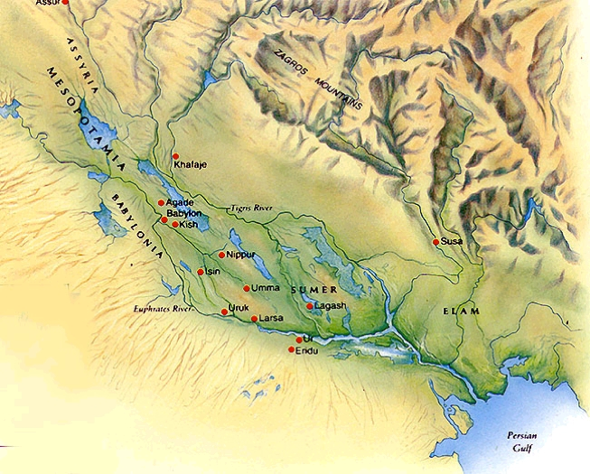
This map os to show all the city states that were involved in ancient day Iraq and the distance between them. You can see for yourself on the map which city-states seem to be closer to water sources and rich soil.
Citation: Mesopotamia Relief Map. (n.d.). Retrieved September 02, 2016, from https://geopolicraticus.files.wordpress.com/2014/01/mesopotamia-relief-map.jpg |

|
|
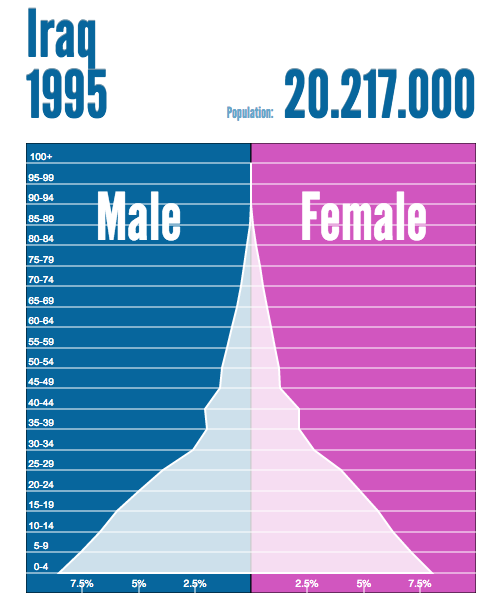
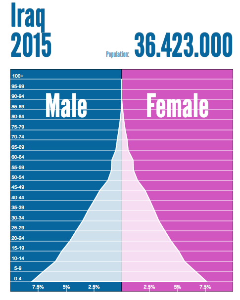
In the two graphs above, it is clear to see that the population growth continues to grow rapidly. I picked the year I was born in (1995) and the most current year passed (2015). In 2015 you can see the age groups from birth to the ages between 50-54 are pretty large. In Iraq, families are encouraged to have children, despite the large amount of poverty going on. This is because they can get children in work places as soon as possible so that they can have a large population in the world to provide protection and safety.
Works Cited
Essay, B. R. (2014). Cultural, Population and Settlement Patterns of Iraq. Retrieved September 02, 2016, from http://www.geographynotes.com/essay/cultural-population-and-settlement-patterns-of-iraq/324
Sites, B. G. (n.d.). Ancient Iraq (Mesopotamia) - Ancient Civilizations for Kids. Retrieved September 03, 2016, from https://sites.google.com/site/1ancientcivilizationsforkids/ancient-iraq-mesopotamia
The Sumerians. (2005). Retrieved September 03, 2016, from http://www.iraqiembassy.us/page/the-sumerians
